
Explore Northern California Hiking Areas with Maps by Ben Pease
The Walker’s Map of San Francisco, 3rd Ed.
Ben Pease
This map is the perfect companion for San Francisco residents and visitors who want to move beyond the expected destinations, and explore hidden treasures, from Chinatown alleys to quiet neighborhoods and busy shopping streets.
Trail Map of Pacifica
Ben Pease
This handsome, easy-to-read map shows trails for hiking, bicycling and equestrians in the splendid coastal area immediately south of San Francisco. Includes Sweeney Ridge and Milagra Ridge areas of Golden Gate NRA, Montara Mountain, McNee Ranch State Park, five state beaches, county and city parks and more. Back of map describes parks, areas open to dogs, and public transit available.
Trails of Mt. Tamalpais, Muir Woods and Marin Headlands, 2nd Edition
Ben Pease
The 2019 edition of this classic guide to the Bay Area’s favorite mountain has been gently updated with accurately-mapped trails and clear bike access.
Trails of Northeast Marin County, 2nd ed.
Ben Pease
This handsome, easy-to-read map shows trails for hiking,bicycling and equestrians in China Camp State Park, Olompali State Park, 17 Marin Open Space Preserves, four county parks, the Big Rock Ridge Area of Marin Open Space District, and more. Text describes trails, parks, areas open to dogs, and public transit available.
Trails of Northern San Mateo County Coastside, Skyline & Foothills
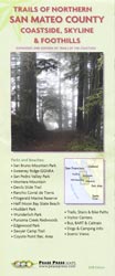
Ben Pease
Complete map of parks and beaches from Daly City/Pacifica south to Half Moon Bay and Woodside. Shows 30 miles of coast and beaches south of San Francisco.
Trails of Santa Cruz, 4th Edition
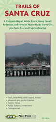
Ben Pease
This handsome and easy-to-read map includes beaches from Davenport to Aptos, plus expanded trails at Wilder Ranch, H. Cowell Redwoods, Forest of Nisene Marks, and UCSC.